")
")


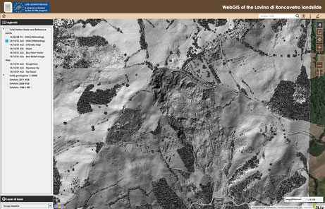
Roncovetro Landslide field survey

On the 28 May 2014, the teams of DST UNIFI and INGV went on the Roncovetro Landslide in order to carrying out a first field survey. The two team of researches were guided by the geologist Giovanni Bertolini of Regione Emilia Romagna.
The objectives of the survey were:
- observation of the morphology and evaluation of the state of activity of the landslide;
- individuation of stable points for the installation of the total station;
- laser scanner and GPS surveys for producing a reference acquisition in order to measure possible displacements with future acquisitions;
- individuation of active parts of the landslide that may be optimal for the installation of Wi-GIM, with special reference to the distance and the line of sights among the nodes
- plan the airborne LIDAR survey